
The consecration of the Shri Ram Janmabhoomi Temple in Ayodhya on January 22, 2024 marked one of the most historic moments in modern Indian history. Since then, Ayodhya has transformed into one of the busiest pilgrimage destinations in the world, welcoming tens of millions of devotees every year who come to seek the blessings of Lord Shri Ram Lalla.
In 2026, the temple continues to be a deeply spiritual magnet for devotees from every corner of India and the globe. With millions arriving daily — especially during major festivals like Ram Navami, Diwali, and Vivah Panchami — knowing how to book your darshan, Aarti pass, or VIP entry in advance can make all the difference between a peaceful, sacred experience and hours of waiting in the heat.
This complete guide covers everything you need to know about Ayodhya Ram Mandir Darshan Booking 2026 — from the free Sugam Darshan to the coveted Aarti passes and VIP entry options.
About Shri Ram Janmabhoomi Temple, Ayodhya
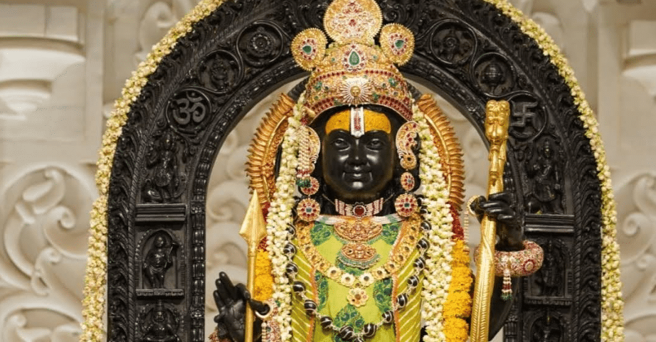
The Shri Ram Janmabhoomi Mandir stands on the sacred ground traditionally believed to be the birthplace of Lord Shri Ram — the seventh avatar of Lord Vishnu and the hero of the timeless epic, the Ramayana. The temple’s architecture follows the Nagara style, crafted entirely from pink sandstone sourced from Rajasthan’s Bansi Paharpur quarries.
The main idol — Ram Lalla (the infant form of Lord Ram) — is enshrined in the garbhagriha (sanctum sanctorum). The complex is spread over 70 acres and includes multiple smaller shrines, a museum, a library, a yatri facilitation center, and lush gardens.
The temple is managed by the Shri Ram Janmabhoomi Teertha Kshetra Trust, which oversees darshan, security, and pilgrim facilities.
Types of Darshan at Ram Mandir Ayodhya in 2026
Understanding the different darshan options helps you choose the one best suited to your needs:
1. Free Darshan (Samanya / General Darshan)
Open to all devotees without any charge. No prior booking is required, but wait times can stretch from 2 to 6+ hours during peak seasons and weekends. This queue is managed by temple authorities and UP Police.
2. Sugam Darshan (Free Online Booked Darshan)
Sugam Darshan is a free darshan with a pre-booked time slot, allowing devotees to skip the general queue and enter through a dedicated lane. This is arguably the most practical option for most visitors — it costs nothing, but requires advance online registration.
✅ Highly Recommended: Sugam Darshan is the ideal choice for families, senior citizens, and those who value their time. Always book this before traveling to Ayodhya.
3. Special / VIP Darshan
A premium darshan option that provides significantly shorter wait times and often closer proximity to the deity. Fees apply. Slots are limited and fill up quickly.
4. Aarti Darshan Pass
The temple holds multiple aartis throughout the day — the Shringar Aarti (early morning), Madhyahna Aarti (midday), Sandhya Aarti (evening), and Shayan Aarti (night). Passes to attend these aartis are highly sought after and must be booked separately online. Witnessing the aarti in person is a profoundly moving spiritual experience.
5. Special Puja & Archana Services
Devotees can book personal puja services like Rudrabhishek, Ramayana Path, Sahasranama Archana, and dedicated offerings in the name of their family. These services are offered at varying donation amounts.
How to Book Ayodhya Ram Mandir Darshan Online in 2026
The official booking platform for Ram Mandir darshan is managed by the Shri Ram Janmabhoomi Teertha Kshetra Trust in coordination with the Government of Uttar Pradesh.
Official Booking Website
Also accessible via the “Shri Ram Janmabhoomi” mobile app, available on both Google Play Store and Apple App Store.
⚠️ Warning: Many fake websites and agents claim to offer Ram Mandir darshan bookings. Always use only the official website or app. The Trust does not authorize any third-party agents for bookings.
Step-by-Step Guide to Book Sugam Darshan
Step 1: Visit the Official Website or App Go to https://srjbtkshetra.org or open the official mobile app.
Step 2: Register or Log In Create a new account using:
- Your mobile number (OTP verification required)
- Email address
- Full name as per government ID
Step 3: Select “Sugam Darshan” On the dashboard, click on “Sugam Darshan Booking” and select your preferred visit date.
Step 4: Choose Your Time Slot Available time slots will be displayed. Select the one that fits your schedule. Slots during early morning (6–9 AM) and evening (5–8 PM) fill up fastest.
Step 5: Add Devotee Details Enter details for all members in your group:
- Full names
- Age
- Gender
- ID proof type and number
The maximum number of persons per booking may be capped (usually 6 per booking ID).
Step 6: Confirm Booking Review all details and confirm your booking. Since Sugam Darshan is free, no payment is required. You will receive a booking confirmation via SMS and email.
Step 7: Download Your Pass Download the e-pass (PDF) or save the QR code to your phone. At the temple, show this QR code at the Sugam Darshan entry gate along with your original photo ID.
How to Book Aarti Darshan Pass
Aarti passes are separate from the general darshan booking and must be booked independently.
Step 1: Log in to the official website/app.
Step 2: Select “Aarti Pass Booking” from the menu.
Step 3: Choose the specific aarti you wish to attend:
- Shringar Aarti – Early morning (approx. 6:00–7:00 AM)
- Rajbhog Aarti – Mid-morning (approx. 10:00 AM)
- Madhyahna Aarti – Afternoon
- Sandhya Aarti – Evening (approx. 6:30–7:30 PM) (Most popular)
- Shayan Aarti – Night (approx. 9:30–10:30 PM)
Step 4: Select your date and the number of passes.
Step 5: Fill in devotee details and confirm. A donation amount may be applicable for Aarti passes depending on the service.
Step 6: Download your Aarti pass with QR code. Arrive at the temple at least 30–45 minutes before the aarti time as seating is arranged in a specific area.
🔔 Pro Tip: The Sandhya (Evening) Aarti is the most spectacular and emotionally moving. Book this well in advance — passes are released on the website and get booked within minutes during peak seasons.
How to Book VIP / Special Darshan
VIP darshan provides priority access with minimal waiting. Here’s how to book:
Step 1: On the official website, navigate to “Special Darshan” or “VIP Darshan Booking.”
Step 2: Select your date, time slot, and the number of persons.
Step 3: Fill in devotee details and proceed to payment. Fees are typically in the range of ₹300–₹500 per person (subject to change).
Step 4: Complete payment via UPI, Net Banking, or card.
Step 5: Download your VIP darshan pass and present it at the dedicated VIP entry gate.
📌 Note: VIP passes are strictly non-transferable and require matching government ID at the entry gate.
Aarti Timings at Ram Mandir Ayodhya 2026
| Aarti Name | Approximate Time | Description |
|---|---|---|
| Shringar Aarti | 6:00 AM | Morning adornment ritual; most serene |
| Rajbhog Aarti | 10:00 AM | Mid-morning offering aarti |
| Madhyahna Aarti | 12:00 PM | Noon aarti; shorter duration |
| Sandhya Aarti | 6:30–7:30 PM | Evening aarti; most popular and grand |
| Shayan Aarti | 9:30–10:00 PM | Night aarti; intimate and deeply devotional |
Timings may vary by season. Always confirm on the official website before your visit.
Darshan Booking Tips for 2026
Book as Early as Possible: Sugam Darshan slots, especially for weekends, Mondays (auspicious for Lord Ram), and festival days, get fully booked days or even weeks in advance. Book the moment your travel dates are confirmed.
Choose Weekday Visits: Weekdays, particularly Tuesday through Thursday, tend to be less crowded than weekends and Mondays.
Carry Multiple ID Copies: Every person in your group must carry their original government ID. Digital copies on your phone alongside printed copies are strongly recommended.
Arrive Early: Even with a booked slot, arrive 30–45 minutes early to account for security checks, shoe deposit, and entry procedures.
Use the Official App: The mobile app is often faster and more responsive than the website during high-traffic periods.
Check Slot Availability Regularly: If your preferred date shows no availability, check back every few days. Cancellations do occur and new slots are sometimes released closer to the date.
Important Rules & Guidelines for Temple Visit
Dress Code: Traditional Indian attire is strongly preferred and respected. Men may wear dhoti-kurta or formal traditional dress. Women should wear saree, salwar kameez, or similar modest clothing. Western casuals like shorts, sleeveless tops, or revealing outfits are not appropriate and may result in entry refusal.
Prohibited Items: The following are generally not permitted inside the temple complex: leather items (belts, wallets, bags), mobile phones and cameras (in certain areas), tobacco and tobacco products, outside food and drinks, sharp objects, and large bags or luggage.
Shoe Deposit: Footwear must be removed and deposited at the designated joota ghar (shoe deposit counters) outside the temple. Keep your token safe.
Cloak Rooms: Lockers and cloak room facilities are available for storing bags, electronics, and other belongings.
Security Checks: All devotees go through thorough security screening. Cooperate with CISF and temple security personnel patiently.
Physically Challenged Devotees: Special ramps, wheelchairs, and assistance are available for differently-abled and elderly devotees. Contact the Yatri Facilitation Center on arrival.
Key Festivals at Ram Mandir Ayodhya in 2026
Visiting Ayodhya during a major festival transforms the spiritual experience manifold. However, these periods require booking significantly in advance:
| Festival | Approximate Date (2026) | Significance |
|---|---|---|
| Ram Navami | April 6, 2026 | Celebration of Lord Ram’s birth; grandest festival |
| Hanuman Jayanti | April 23, 2026 | Celebration of Lord Hanuman’s birth |
| Vivah Panchami | November 25, 2026 | Celestial wedding of Ram and Sita |
| Diwali (Deepotsav) | October 20, 2026 | Lakhs of diyas lit across Ayodhya; spectacular |
| Parikrama Mela | Various | Monthly and special parikrama events |
| Makar Sankranti | January 14, 2026 | Auspicious bathing and darshan |
🎆 Ram Navami and Diwali are the two most important and crowded festivals. The Ayodhya Deepotsav (Diwali celebration) in recent years has seen record-breaking lamp lighting ceremonies along the Saryu riverbank. Plan your stay and bookings at least 2–3 months ahead for these festivals.
How to Reach Ayodhya in 2026
Ayodhya is now extremely well-connected to all major cities following major infrastructure improvements:
By Air: The newly upgraded Maharishi Valmiki International Airport, Ayodhya (AYJ) operates flights from Delhi, Mumbai, Chennai, Bengaluru, Ahmedabad, Kolkata, and other major cities. This is the most convenient option for long-distance travelers.
By Rail: Ayodhya has two major railway stations — Ayodhya Junction and Ayodhya Cantt. Numerous express and superfast trains connect Ayodhya to Delhi (Anand Vihar/New Delhi), Mumbai (LTT), Varanasi, Lucknow, Patna, Kolkata, and beyond. Special pilgrimage trains (Aastha Special) are also operated during peak seasons.
By Road: Ayodhya is connected via the Purvanchal Expressway and National Highways. Distance from Lucknow is about 135 km (2.5–3 hours); from Varanasi about 200 km (3–4 hours); from Delhi about 650 km (10–11 hours by road or 7–8 hours via expressway).
By Bus: UP State Road Transport Corporation (UPSRTC) and private luxury buses operate regular services from Lucknow, Varanasi, Allahabad (Prayagraj), Gorakhpur, and Delhi.
Where to Stay in Ayodhya
Ayodhya has seen a massive expansion in accommodation options since 2024:
Dharamshalas & Ashrams: Numerous religious organizations and trusts run affordable or free dharamshalas in Ayodhya. These are basic but clean, and ideal for pure pilgrimage-focused trips.
Budget Hotels: Many budget hotels and guesthouses have come up near the Ram Mandir complex and in the main city area, with rates typically between ₹800–₹2500/night.
Mid-Range Hotels: Comfortable hotels with modern amenities are available at ₹2500–₹6000/night. These fill up quickly during festivals.
Luxury Hotels & Resorts: Several reputed hotel chains have established properties in and around Ayodhya to cater to the growing pilgrim-tourism demand. These range from ₹6000–₹20,000+/night.
🏨 Booking Tip: For Ram Navami and Diwali, accommodation should be booked at least 3–4 months in advance. For regular weekends, 2–3 weeks in advance is advisable.
Nearby Places to Visit in Ayodhya
Ayodhya is a city steeped in spiritual history. Beyond the Ram Mandir, there is much to explore:
Hanuman Garhi: A 76-step climb leads to this powerful temple of Lord Hanuman, the guardian of Ayodhya. Visiting Hanuman Garhi before Ram Mandir is considered auspicious — tradition holds that Lord Hanuman must be greeted first.
Kanak Bhawan: A beautiful golden temple believed to be the private palace gifted to Sita and Ram by Queen Kaikeyi after their marriage. The golden idols of Ram and Sita are breathtaking.
Saryu River Ghat: A dip in the sacred Saryu river is considered deeply purifying. The evening Ganga Aarti-style ceremony at the ghats is a serene experience.
Nageshwarnath Temple: One of the oldest temples in Ayodhya, dedicated to Lord Shiva. Said to have been established by Kush, the son of Lord Ram.
Treta Ke Thakur: The spot where Lord Ram is believed to have performed the Ashwamedha Yajna. The idols here are made from the original black stone of the former Ram Mandir.
Ram Ki Paidi (Ghats): A series of beautiful steps leading down to the Saryu river, especially magical during Diwali when thousands of oil lamps are lit.
Sita Ki Rasoi: Near the Ram Janmabhoomi complex, this is the mythological kitchen of Goddess Sita — one of Ayodhya’s unique and deeply revered sites.
Frequently Asked Questions (FAQs)
Q: Is Sugam Darshan booking truly free? A: Yes. Sugam Darshan is completely free of charge. You only need to register online, select a time slot, and show your e-pass at the temple. No payment is required.
Q: How many days in advance can I book? A: Bookings typically open 15–30 days in advance. Check the official website for the current booking window.
Q: Can I visit without an online booking? A: Yes. General/free darshan is available without any booking. However, wait times can be very long, especially on weekends and festivals.
Q: Is there a limit on the number of people per booking? A: Yes. Generally, a single booking allows up to 6 persons. For larger groups, multiple bookings may be required.
Q: Are foreign nationals allowed to visit Ram Mandir? A: Yes. Foreign nationals are welcome. A valid passport is required as ID proof.
Q: Can I book darshan for someone else? A: You can enter the details of other group members when booking. However, the ID submitted during booking must be carried by each individual at the time of entry.
Q: What happens if I miss my booked slot? A: Missed slots are generally forfeited. You would need to join the general queue or rebook. It is advisable to arrive well before your allotted time.
Q: Is photography allowed inside the temple? A: Mobile phones and cameras are restricted in certain areas, particularly near the sanctum sanctorum. Always follow the instructions of temple security personnel.
Final Thoughts
The Shri Ram Janmabhoomi Temple in Ayodhya is far more than a place of worship — it is the living fulfillment of a centuries-old prayer, a symbol of faith, devotion, and cultural heritage for hundreds of millions of people. Standing before Ram Lalla in the sanctum of this magnificent temple, even the most reserved heart cannot help but feel moved.
In 2026, with better infrastructure, improved online booking systems, and expanded facilities for pilgrims, visiting Ayodhya is more accessible than ever before. Whether you choose the serene Shringar Aarti at dawn, the emotionally charged Sandhya Aarti at dusk, or a peaceful Sugam Darshan with your family, every moment spent in the presence of Lord Ram is one that stays with you for a lifetime.
Plan ahead. Book early. Travel with devotion.
Jai Shri Ram! 🙏